Science-Based Landscape Water Reduction for the Modern West.
The Plant Institute Inc. researches and deploys advanced canopy management, irrigation optimization, plant physiology systems, and water-smart education programs designed to reduce outdoor landscape water demand while improving plant health and urban environments.
In arid-region homes, landscapes waste more water than anything else.
Outdoor irrigation is the single largest residential water expense in most arid and semi-arid regions, and most of it is engineered wrong.
of residential water in arid-region homes is used outdoors.
Landscape irrigation, not showers, dishwashers, or toilets, is the single biggest residential water line in most Western U.S. utilities.
evapotranspiration losses are typical on poorly pruned canopies.
Research on canopy structure and irrigation efficiency consistently finds that shade architecture and irrigation tuning are the dominant levers on landscape water demand.
on the Colorado River Basin.
Every city tied to the Colorado is under conservation pressure, and most are passing it to property owners through tiered rate increases.
What is the JLB Canopy Management System?
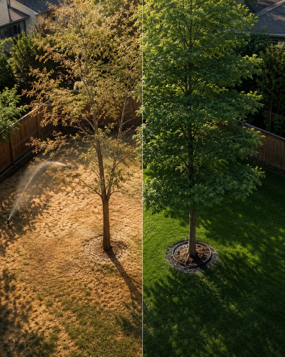
The JLB Canopy Management System is a research-based protocol for reducing a landscape's water demand at the canopy and irrigation level. We do not install artificial turf. We do not rip out your yard. We engineer the canopy you already have and tune the irrigation that runs underneath it, working alongside our GreenRx soil and irrigation optimization protocol.
JLB Canopy Management System™
- Structural pruning designed to reduce evapotranspiration load.
- Layered canopy architecture that creates self-shading microclimates.
- Keeps mature plants within the bounds set by the landscape, and never requires removal.
GreenRx™ Plant Optimization Protocol
- Soil-zone diagnostics: infiltration, compaction, root-zone health.
- Irrigation flow and nozzle adjustments tuned to match each plant's actual water demand.
- Irrigation-controller recalibration paired with the optimized plantings already in place.
From first call to verified savings in four steps.
Free Water Savings Analysis
We overlay satellite canopy mapping on your address and return a written ballpark reduction forecast. No cost. A property-specific number requires the site walk in step 2.
Site walk & soil diagnostics
A JLB-certified field researcher visits the property, takes soil cores, measures canopy density, and audits the irrigation controller.
Custom JLB + GreenRx prescription
You receive a plant-by-plant, zone-by-zone plan with projected gallons saved and payback period.
Implementation & verification
JLB-certified crews execute. We monitor water-meter data for 12 months and publish a verification report.
Our reduction targets, and the research behind them.
Our program is designed around peer-reviewed canopy-management and irrigation-efficiency research, and scoped so every project includes a 12-month post-install verification, not just an estimate.
Reductions are design targets, not guarantees: we never control 100 percent of how your irrigation controller is operated after install, so we cannot promise an outcome we cannot enforce. We publish results from our active measurement cohort as projects reach 12 months post-install.
How a JLB-optimized yard compares to standard and xeriscape options.
Three single-family residential landscape options, side by side. A standard irrigated yard, a full xeriscape conversion, and a JLB-optimized yard. The numbers are expressed in both gallons and acre-feet, the unit water districts use when they plan supply.
| Landscape type | Annual water use | Acre-feet |
|---|---|---|
| Conventional landscape | 104,000 gallons | 0.32 AF |
| Xeriscape landscape | 48,600 gallons | 0.15 AF |
| JLB-optimized landscape | 56,550 gallons | 0.17 AF |
Representative single-family residential figures used in JLB program design modeling. The xeriscape row reflects rock or synthetic conversion at footprint scale. The JLB-optimized row keeps living canopy and turf, reaching close to xeriscape water savings without the heat, ecological, and aesthetic cost.
Built for every scale of landscape.
HOMEOWNERS
Cut your bill, keep your yard
Reduce your summer water bill 30 to 50 percent without losing the yard you love.
Estimate your savings ↓HOAS & COMMUNITIES
Board-approved reductions
Lower common-area irrigation costs while preserving curb appeal and board satisfaction.
Estimate your savings ↓CITIES & ENTITIES
Municipal-scale outcomes
Pilot programs, corridor-scale reporting, and grant-aligned environmental outcomes.
Municipal programs ↓Removing your lawn for rock or synthetic turf usually makes everything around it worse.
Conventional xeriscape (turf removal followed by rock mulch or artificial turf) saves water on its own footprint, but it radiates heat into the adjacent canopy, accelerates transpiration on the remaining plants, raises the urban heat island, and undermines the very water savings the conversion was supposed to deliver.
ROCK MULCH
High thermal mass
Rock absorbs solar radiation through the day and re-radiates it as long-wave heat into adjacent plants for hours after sunset. The surrounding canopy responds with elevated transpiration, which raises the water demand of every plant near the rock. The savings on the rock footprint are partially eaten by the higher demand next to it.
ARTIFICIAL TURF
Surface temperatures above 150°F
Synthetic turf in direct mid-summer sun routinely exceeds the surface temperatures of natural turf, asphalt, and even rock mulch. That is high enough to be unsafe for direct contact and high enough to heat-stress everything growing next to it.
BETTER ALTERNATIVE
Optimization, not removal
JLB canopy management plus GreenRx soil and irrigation tuning reaches near-xeriscape water savings while keeping the living canopy, working turf, and ecological function the yard already has.
Grounded in public data and peer-reviewed research.
We publish methodology alongside outcomes. Our baseline water-use assumptions, climate normals, and reduction targets come from the public data sources below, cross-referenced with peer-reviewed canopy, transpiration, turf, and urban-heat research from leading research institutions.
FEDERAL DATA
USGS
Hydrologic data, terminal-lake elevation records, watershed inflow measurements, and arid-region groundwater monitoring used in our acre-foot modeling.
FEDERAL DATA
USBR
U.S. Bureau of Reclamation reservoir storage and Colorado River Basin allocation data referenced in our supply-side context.
STATE DATA
State Divisions of Water Resources
Municipal and industrial water-use reports, outdoor-use percentage, and per-capita benchmarks from the state agencies in our service regions.
RESEARCH
Utah State University Extension
Landscape, irrigation, canopy, and soil research applicable to high-desert and arid-climate residential horticulture.
RESEARCH
Arizona State University
Urban-heat-island research, microclimate science, and arid-region horticulture science from ASU's Sustainability and Urban Climate programs.
RESEARCH
US Forest Service
Urban forestry, canopy thermal, and tree-water-use research relevant to municipal-scale heat and water management.
FEDERAL IMAGERY
NASA Earth Observatory
Public satellite imagery and analysis of regional drought, reservoir storage, and terminal-lake conditions.
RESEARCH
Canopy & transpiration literature
Peer-reviewed studies on plant canopy density, transpiration rates, and how leaf surface area and shade architecture affect outdoor water use.
UTILITY DATA
Regional water districts
Rate structures, restriction calendars, and rebate program details from the utility districts in cities where our work is active.
Rounded ranges throughout are framed as program design standards, not measured outcomes or guarantees. The Plant Institute Inc. maintains its methodology and cohort data internally and provides it on request to journalists, grant reviewers, and partner municipalities. Contact info@plantinstitute.org for documentation.
Cut landscape water use across yards by measurable margins, without removing the landscape.
The Plant Institute Inc. is dedicated to advancing sustainable landscape stewardship through scientific research, education, and applied innovation. Our mission is to reduce urban landscape water demand, improve plant health, and increase environmental resilience by connecting research with practical, field-tested solutions that benefit people, plants, and the ecosystems upon which we depend.
The Plant Institute Inc. is a registered 501(c)(3) nonprofit organization. EIN 92-3514746. Contributions are tax-deductible to the extent allowed by law.
Research-first
We publish methodology before we publish results. Our reduction forecasts are built from peer-reviewed canopy, transpiration, and irrigation-efficiency research, not marketing.
Verified at the meter
Every project includes a 12-month post-install verification using the homeowner's or property's own meter readings, taken on the same date one year apart. Not modeled estimates.
Become JLB-certified, homeowner or professional.
JLB Certification is our education and credentialing program. We teach the canopy management, irrigation optimization, and plant physiology methodology that drives 30 to 60 percent landscape water reduction. The homeowner track is for owner-operators who want to apply it themselves. The professional track is for landscape contractors, arborists, and irrigation pros who want to deliver it to their clients to a research-backed standard.
Homeowner Certification
- AudienceOwner-operators of single-family residential property
- FormatSelf-paced online modules plus a field verification (before-and-after meter readings and photo documentation)
- DurationApproximately 8 to 12 hours of coursework, with a year-out follow-up reading
- OutcomeApply JLB to your own property under JLB guidance, with documented results
Professional Certification
- AudienceLandscape contractors, arborists, irrigation pros, HOA landscape managers
- FormatOnline modules plus a multi-day field practicum
- DurationApproximately 40 to 60 hours plus practicum
- OutcomeDeliver JLB to client properties at the JLB standard, listed in the certified-pro directory
Scale the methodology from a single yard to a city corridor.
Our largest impact comes from corridor-scale and citywide deployments. We design pilot programs, deliver grant-compliant data packages, and publish results the city or partnering entity can defend publicly. Our pilot tiers are sized to produce a statistically valid sample, so the results survive an audit. The 2026 cohort is open.
SEED PILOT
500 to 1,000 parcels
One conservation-pressure corridor, 4 to 6 months, JLB absorbs a portion of cost under research-partnership status. Sample size is set to filter outliers and produce a statistically valid result.
VERIFIED PROGRAM
1,000 to 2,000 parcels
Multi-corridor, multi-season, blended grant-to-entity funding. USBR WaterSMART and state water-resource grant alignment.
CITYWIDE DEPLOYMENT
2,000+ parcels
Full residential or mixed audience, blended federal, state, and utility capital funding, 24 to 36 months.
See your projected water savings in 30 seconds.
This calculator uses JLB's design-standard reduction ranges. Your written Free Water Savings Analysis produces a property-specific forecast.
Your projected savings
Estimates use JLB's published design-standard reduction midpoints. Your written analysis produces a property-specific forecast based on a site visit, soil cores, and canopy and irrigation audit.
Get my verified analysisCommon questions.
Are you a landscaping company?
Will I have to remove my lawn or trees?
How is this different from xeriscaping?
Is there a cost to the initial analysis?
Do you work with cities and utilities?
Where do you operate?
Are contributions tax-deductible?
The water you're wasting has a number. We'll send it to you, free.
The online forecast is free: a written reduction estimate within 5 business days, no sales call. The on-site site walk and audit is a separate, paid step.
501(c)(3) nonprofit. 5-day turnaround.
Free Water Savings Analysis
We reply within one business day.
Donate to The Plant Institute Inc.
The Plant Institute Inc. is a 501(c)(3) nonprofit (EIN 92-3514746). Contributions are tax-deductible and fund our field research, the JLB certification curriculum, and the meter-level verification work we publish each year. To make a tax-deductible contribution today, email info@plantinstitute.org or call (801) 859-3191; we accept check, ACH, donor-advised fund grants, and matching-gift program submissions, and we provide a receipt for your records.
BY EMAIL
info@plantinstitute.org
Tell us you'd like to donate and we'll send a giving link or a mailing address for a check. We'll send a tax-deductible receipt for your records.
Email to give →ABOUT YOUR GIFT
What your support funds
Field research on canopy transpiration and irrigation efficiency, JLB certification curriculum and field practicum costs, and the 12-month meter-level verification reports we publish on every project.